by Britt Bauer**
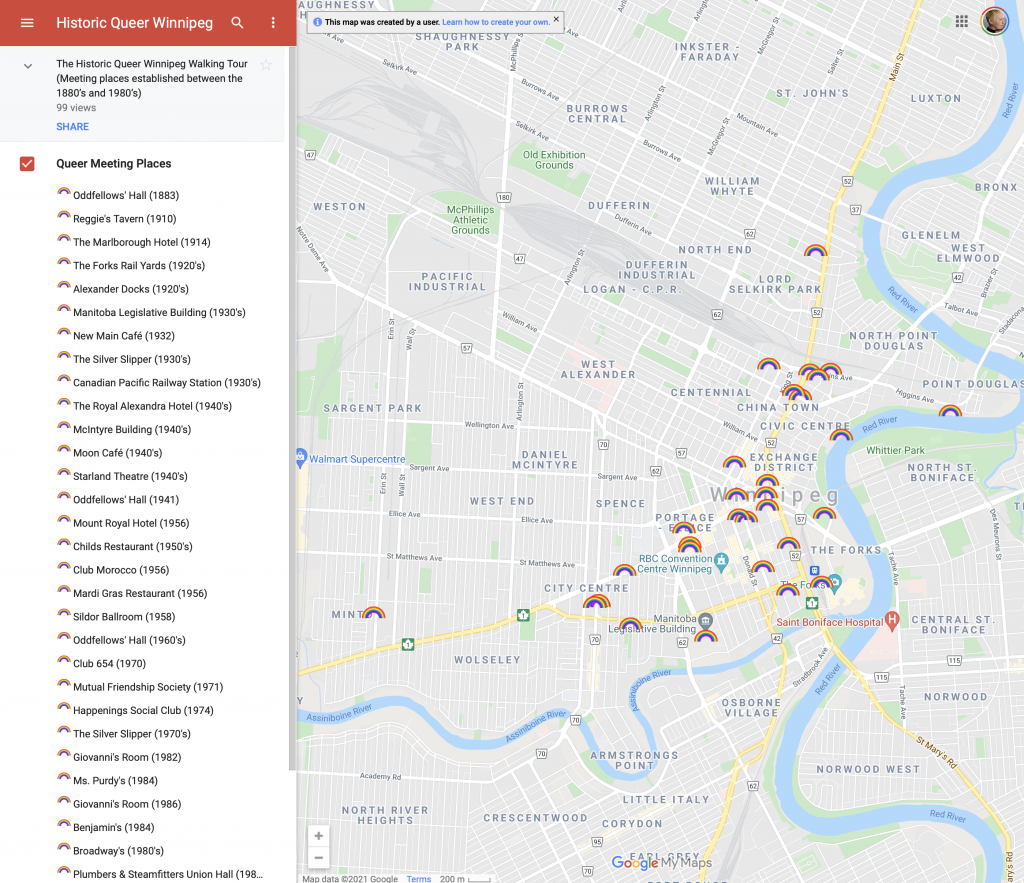
The walking tour is available here on Google Maps.

At a time when BIPOC, 2SLGBTQ+, and women’s contributions and histories are underrepresented, misrepresented, or are completely absent from museum displays (see Failler, Ives & Milne), I thought it would be a good time to flip the idea of the museum on its head: seeing Winnipeg as a museum. It is an opportunity to experience history outside of fixed physical spaces in order to free oneself from the often ridged, political constraints of institutions.
The Historic Queer Winnipeg walking tour is located on Treaty One Territory, traditional territory of the Anishinaabeg, Cree, Oji-Cree, Dakota, and Dene Peoples, and on the homeland of the Métis Nation. This walking tour is free, and you can do it whenever you want, at your own speed. You can even tour the city from your home computer, while accessing historic photos, interviews, videos, blogs, and articles. This is all to show the viewer that Winnipeg is a museum, filled with memories of love, danger, dancing, fear, and friendship. I believe it is important to remember the queer folks who lived here before us, and fought for the rights we have to love and exist today.
After extensive searches through newspapers, podcasts, articles, and archival interviews, I have found 32 locations* that have served as safe spaces for queer people at various points of time. On the tour you will see historic buildings built as early as 1883, outdoor meeting places, and places where buildings used to be. This includes Winnipeg’s first gay club, Winnipeg’s first women-only/lesbian club, and the city’s first drag queen club. This tour through time demonstrates that we have always been here. These are building that we walk or drive past every day, and yet we are unaware of the layered histories of these places, and the memories and ghosts that inhabit them. These histories have been concealed, and the information that is accessible to the public is scattered and fragmented. It is my hope that having all of this information in one place can lead to more awareness, and a celebration of 2SLGBTQ+ history in Winnipeg. All of this said, we still have a lot of work to do in our communities. We have to acknowledge that while we do have queer spaces now, racism, transphobia, and misogyny still exist in them. This tour through Winnipeg’s queer past, and the queer history media embedded in the map will show how much of a journey it was to get others to recognise our rights, and that the job is not done until our Queer spaces are fully accessible, inclusive, and safe for all who need them.
While you are here, check out the One Queer City ads that are up around Winnipeg!
A big thank you to Angela Failler, Heather Milne, Nicole Ritchie, and Lauren Bosc for all of your guidance, feedback, and support while I worked on this project.
*I will be adding more locations and information as I unearth them, with a focused effort to add as much historical QTBIPOC content as possible.
**Britt Bauer is currently a student in the Cultural Studies MA program at the University of Winnipeg, and she received her undergraduate training in both Environmental Studies and Classics. Her work primarily focuses on underrepresented aspects of classical scholarship such as the lives of queer women and the poor. She is currently engaged in projects centred on recreating foodways and pathways of the poor in Roman Italy via ethnoarchaeology and experimental archaeology.
